Breve reseña de los sismos provenientes de la falla geológica de Quito que han afectado a la Capital
por Hugo Yepes A.
La última vez que Quito sufrió daños por un terremoto fue en 1990, en la noche del 10 de Agosto, en que un temblor de magnitud Mw 5.3 (Mw es una escala universal de magnitud que relaciona la energía sísmica liberada por el terremoto con las características físicas de la falla geológica que lo produce) ubicado a escasos dos kilómetros al norte del epicentro del temblor del día 12 de Agosto de 2014 (Mw 5.1), destruyera casas de adobe y tapial en un radio de 12 km a la redonda, además de algunas construcciones modernas sobre todo en las zonas de Pomasqui y Pusuquí.
Estos dos eventos sísmicos están relacionados con la estructura geológica conocida como la falla o el sistema de fallas de Quito, que corre al Este de la ciudad a lo largo de las pendientes que miran hacia los Valles de Tumbaco y los Chillos, colinas que marcan el borde oriental de la ciudad y que las conocemos como las lomas del Tablón frente a Amaguaña, Puengasí, Ilumbisí, El Batán, La Bota y Bellavista-Catequilla en el extremo Norte de la estructura pasando Calderón. Se trata de una falla inversa, es decir que uno de los bloque (el de Quito) se levanta respecto del otro (los valles) en contra de la fuerza de gravedad por fuerzas de compresión tectónica que empujan al continente desde el Occidente. Es esta la razón por la que Quito, a fuerza de sismos repetitivos en la historia geológica de su cuenca se levanta unos 400 metros sobre el nivel del Valle Interandino.
Pero éstos no son los únicos sismos provenientes de la falla de Quito que han sacudido a la Capital. El 16 de Mayo de 1923 un patrón de daños más acentuados en las iglesias de un Quito que se extendía a duras penas desde la Villa Flora hasta la Colón hace presumir que el epicentro en esa ocasión se encontró más hacia el centro de la estructura, en el segmento de Ilumbisí. Coincidentemente en Agosto, el día 9 del año 1938, un fuerte temblor sacudió el Valle de los Chillos, especialmente a Alangasí, Sangolquí y el Tingo, sin que pueda descartarse que también se trate de una ramificación oriental del sistema de fallas de Quito.
En el siglo XVIII descripciones que pierden claridad por el tiempo transcurrido, dan cuenta de daños menores en las iglesias de la época en 1787 por un sismo local de la falla de Quito. Pero en 1755 se reporta un evento que sale del patrón típico de comportamiento de los sismos de la falla de Quito que empieza con un movimiento fuerte y súbito seguido de réplicas menores por varios días. El 26 de Abril de dicho año empiezan los quiteños a sentir temblores fuertes y frecuentes que causan temor y ciertos desperfectos, pero es el 28 de Abril, es decir dos días después de haber empezado la secuencia sísmica, que se suelta gran parte de la energía acumulada y daña todos los templos y casas de Quito, provocando que muchos habitantes salgan de la ciudad buscando protección en el campo. Al no haberse reportado otros estragos en pueblos circundantes, es plausible suponer que fue nuevamente la falla de Quito la causante de estos efectos. Las réplicas perduraron al menos por ocho semanas más.
En 1662 hay posiblemente otro evento atribuible a la falla de Quito. En la fachada de la iglesia de San Agustín se lee: “Año de 1660, rebentó [sic] el volcán de Pichincha. Año de 1662, ocurrió el terremoto”, aunque su relación temporal cercana con la erupción del Guagua Pichincha y la descripción de un deslizamiento importante en el Sincholagua por esas épocas hacen dudar sobre el origen del mencionado sismo que dañó nuevamente iglesias y viviendas.
Finalmente, o más propiamente para iniciar la historia sísmica de la ciudad, está el terremoto de 1587, nuevamente en Agosto, cuando “no vino el temblor avisándonos…., sin ruido; duró obra de dos o tres credos, que si más duraba no quedaba casa ni pared enhiesta” según el padre Provincial de la Compañía de Jesús Juan de Atienza (Burgos, H) y que estuvo ubicado en el extremo Norte de la falla. Investigaciones últimas de sismología histórica le atribuyen una magnitud alrededor de 6.4 (Beauval, Yepes y otros) lo que lo hace cerca de 100 veces más poderoso que el registrado este 12 de Agosto.
En definitiva, en todos los siglos a excepción del XIX, hay uno o más sismos con características alarmantes o destructoras en el sistema de fallas geológicas de Quito, siendo el temblor de este Agosto de 2014 solo una muestra del verdadero potencial sísmico que tienen estas fallas. Otros terremotos provenientes de otras fallas geológicas han causado también muchos estragos en la capital, pero ese es tema para otra discusión.
Grenoble, 13 de Agosto de 2014
Instituto Geofísico
Informe Sísmico Especial N° 1 - Sismo de Quito 12 de agosto 2014
En la tarde de ayer a las 14h57 (TL) se produjo un sismo de magnitud 5.1, localizado al Nor-Oeste de la parroquia de Calderón, al Norte de la ciudad de Quito (Figura 1). Este sismo estuvo seguido por una réplica a las 15h02 (TL) con una magnitud de 4.1 grados. A partir de este periodo se han generado sucesivas réplicas de magnitudes que oscilan entre 1 y 3.9 grados. Hasta el momento se han localizado 44 réplicas (Figura 1). Algunas de estas fueron sentidas por la población especialmente en el sector norte de Quito.
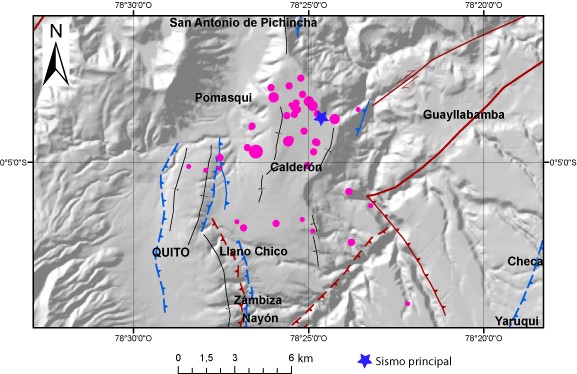
Figura 1. Localización del sismo principal y sus réplicas hasta hoy a las 9h00 TL. Fuente: IGEPN.
El mecanismo de ruptura del sismo principal corresponde a una falla inversa con una dirección NNE-SSW (Figura 2).
Este sismo se generó en una falla que pertenece al denominado Sistema de fallas de Quito. Sobre este sistema de fallas se localiza toda la ciudad de Quito y las parroquias de Pomasqui, Calderón y San Antonio de Pichincha.
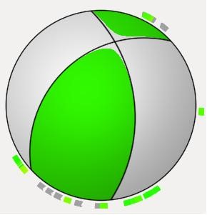
Figura 2. Mecanismo focal obtenido con inversión de formas de onda.
Hay que indicar que una falla tectónica es una fractura de la corteza terrestre que se caracteriza por que puede moverse, cada vez que se mueve se produce un sismo y la magnitud del sismo está en relación directa con el área de ruptura en la zona de falla.
Informe de Evaluación de Intensidades Sísmicas
De acuerdo a los reportes recolectados mediante la aplicación “SINTIÓ EL SISMO” publicado en las redes sociales del IG-EPN, se ha podido evaluar las intensidades macrosísmicas en la escala EMS98.
Hasta el momento de la elaboración de este informe se cuenta con 475 reportes desde Latacunga al Sur hasta Ibarra en el Norte. Se tienen reportes de que el sismo principal (12 de agosto de 2014 14:58) fue sentido en ciudades como Guayaquil, Otavalo, Tulcán y Santo Domingo de los Tsáchilas.
Para la ciudad de Quito se han podido identificar las siguientes intensidades.
|
QUITO |
Intensidad |
|
Sur (Chimbacalle, Quitumbe, Cutuglahua) |
4 |
|
Centro Histórico |
4 |
|
Cetro Norte (El Ejido – Antiguo Aeropuerto) |
4 |
|
Norte (Calderón, Carcelén, Carapungo, Pomasqui) |
5 |
|
Mitad del Mundo |
5-6 |
|
Valle de los Chillos |
4 |
|
Sangolquí |
4 |
|
Tabacundo |
4 |
|
OTRAS CIUDADES |
Intensidad |
|
Santo Domingo de los Tsáchilas |
4 |
|
Los Bancos |
3 |
|
Otavalo |
3 |
|
Machachi |
3 |
|
Latacunga |
2-3 |
|
Ibarra |
3 |
|
Guayaquil |
2-3 |
|
Cayambe |
3 |
La máxima intensidad evaluada fue de 6 EMS al Norte y Nor-oriente de la ciudad de Quito que corresponde a daños leves (no estructurales) a nivel de mampostería (fisuras delgadas en paredes) en edificaciones de bloque o ladrillo. Con esta intensidad, y de acuerdo a los reportes recibidos, la mayoría de personas, tanto dentro como fuera de edificaciones, sintieron el sismo y generó susto en la población.
En la ciudad de Quito, la intensidad promedio fue de 4 EMS que describe a un evento sentido ampliamente por personas al interior de edificaciones, las mismas que observaron objetos livianos en movimiento (vajillas, vasos, lámparas, suenan puertas y ventanas) y se observó movimiento aislado de objetos pesados (muebles, armarios). Con este nivel de intensidad se espera daños no estructurales (fisuras finas en paredes) en muy pocas edificaciones de bloque o ladrillo (generalmente viviendas entre 1 y 2 pisos).
Debido a las características de este evento, se espera que las réplicas se sigan sucediendo durante las próximas horas y días. Hay que indicar que las réplicas son de menor magnitud al sismo principal y su número va decreciendo con el tiempo, algunas de estas seguramente serán sentidas por la población.
AA/MS/JCS
Instituto Geofísico
Escuela Politécnica Nacional
Sismo en la zona de Calderón
Hoy, Martes, 12 de Agosto de 2014, a las 14:57 (tiempo local), la Red Nacional de Sismógrafos (RENSIG) del Instituto Geofísico de la Escuela Politécnica Nacional registró un sismo localizado en la Parroquia de Calderón de magnitud 5.1, y 5 km de profundidad (Figura 1).
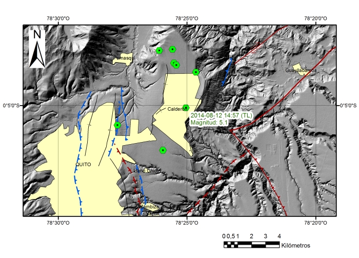
Fig. 1: Localizaciones preliminares del sismo del día de hoy, 12 de agosto (5.1 M) y las réplicas asociadas; estas localizaciones están sujetas a variación a medida que se sigan incorporando más observaciones de la red acelerográfica y sismográfica de la ciudad, lo cual permitirá una mejor determinación de los parámetros hipocentrales. Las líneas de colores en la imagen son las estructuras geológicas activas identificadas en la zona. (Fuente: IGEPN)
Se tienen reportes de que el sismo fue sentido en toda la ciudad de Quito y en los valles aledaños; adicionalmente los reportes recibidos en las redes sociales, indican que también fue sentido en las poblaciones de Ibarra, Tena, El Chaco, Otavalo, Santo Domingo, Urcuquí, Esmeraldas, Baños, El Carmen, Guaranda, Guayaquil, Latacunga, Tulcán.
Posterior a este evento, se registró una réplica de 4.1 grados de magnitud, la cual también fue sentida por la población de las zonas cercanas.
Estos eventos están asociados con el sistema de fallas de Quito, sobre el cual se asienta la ciudad.
MS/DP
Instituto Geofísico
Escuela Politécnica Nacional
Informe del volcán Chiles – Cerro Negro No.14- 2014
Informe del volcán Chiles – Cerro Negro No.14- 2014
Actividad sísmica zona de los volcanes Chiles – Cerro Negro
05 de Agosto de 2014
El presente informe se ha elaborado en coordinación con el Observatorio Vulcanológico y Sismológico de Pasto (OVSP) del Servicio Geológico de Colombia (SGC), y se refiere a la actividad sísmica en la zona de los volcanes Cerro Negro y Chiles, ubicados en la frontera entre Ecuador y Colombia, los cuales se encuentran con cambios en el comportamiento de su actividad volcánica.
Del seguimiento en la última semana, a la actividad de la zona de los Volcanes Chiles y Cerro Negro, se resalta que:
-
- La actividad sísmica asociada con fracturamiento de material cortical continua siendo predominante. En relación con la semana anterior, se registró un ascenso en la ocurrencia de eventos, pasando de 468 eventos (reportados la semana del 23 al 29 de junio) a 601 registrados en la presente semana (del 30 de julio al 05 de agosto). Estos eventos continúan localizándose principalmente al suroccidente del volcán Chiles, a distancias menores a 4 km de este volcán, con profundidades entre 5 y 12.65 km respecto a la cima (nivel de referencia sobre los 4700 msnm) y magnitudes de hasta 2.9 grados en la escala de Richter. En la presente semana no se tuvieron reportes de sismos sentidos por parte de los habitantes de los poblados cercanos.
- La deformación cortical del edifico volcánico registrada en estaciones colombianas, desde el mes de noviembre de 2013, muestra algunas variaciones a partir de abril del 2014.
El análisis de la actividad en la zona de los volcanes Chiles – Cerro Negro y de la amenaza correspondiente con dicha actividad se la continúa trabajando en conjunto con el Observatorio Vulcanológico y Sismológico de Pasto del Servicio Geológico de Colombia.
El Instituto Geofísico de la Escuela Politécnica Nacional continuará atento a la evolución del fenómeno volcánico e informará sobre los cambios que puedan detectarse.
JA/MR
Instituto Geofísico
Escuela Politécnica Nacional
Informe Especial No. 18 de la actividad del Volcán Tungurahua
Actividad eruptiva del Volcán Tungurahua
03 de agosto del 2014
Durante la madrugada y mañana del 02 de agosto, la actividad sísmica y superficial del volcán estuvo asociada a emisiones con cargas moderadas a altas de ceniza. Durante el día se tuvieron reportes de caída de ceniza en los sectores de Choglontús, El Manzano, Motilones, Cusúa, Tisaleo y Mocha. En horas de la tarde de ayer (~18h00) se observó parcialmente una emisión con carga baja de ceniza. En la noche (~20h00), la intensidad de los bramidos fueron más leves, sin embargo a las 19h00, se observó la salida de material incandescente que era expulsado hasta aproximadamente a unos 700 a 1000 m sobre el cráter, y que descendía por los flancos unos 500 a 700 m bajo el nivel del mismo. En momentos en los que se despejó parcialmente el cráter, se registró la emisión continua hacia el nor-occidente a través de la cámara térmica (Figura 1), y con ayuda del visor nocturno se observó de mejor manera la actividad tipo estromboliana (Figura 2).
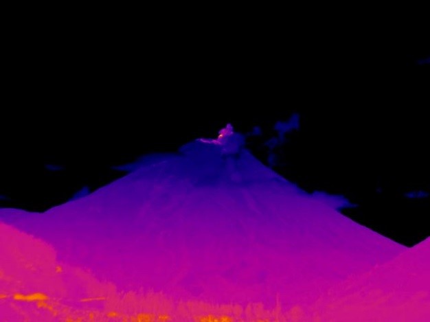
Figura 1. Imagen térmica (19:42) de la emisión continua de ceniza. (Imagen térmica FN. OVT-IG EPN)
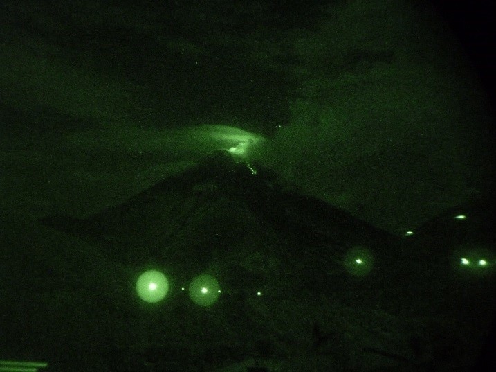
Figura 2. Actividad estromboliana registrada a las 20:15 visto desde el OVT. (Foto. VV. OVT-IG EPN).
Posteriormente a esta fase estromboliana, se registraron cuatro explosiones de tamaño pequeño a moderado, las cuales ocurrieron a las 00h06, 00h22, 00h39 y 00h42. Esta actividad produjo vibración de ventanales en el sector de Bilbao, el rodar de bloques desde el sector de Pondo, bramidos de diferente intensidad y una leve caída de ceniza en los sectores de Bilbao, Pillate, Choglontus y Chacauco. Los depósitos asociados a esta actividad se observaron a través de las imágenes térmicas que muestran los depósitos en el flanco NW del volcán (Figura 3).
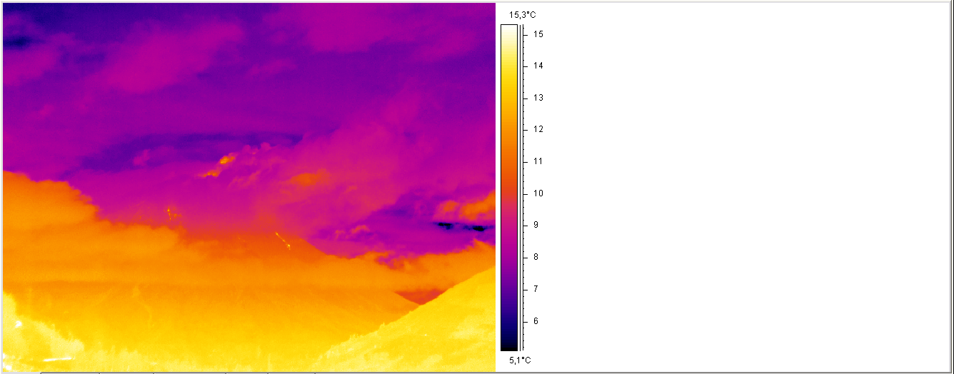
Figura 3. Actividad estromboliana registrada a las 00:44 visto desde el OVT (Imagen térmica FN. OVT-IG EPN).
En horas de la mañana se registraron otras 2 explosiones, a las 07h23 y 07h39, siendo esta última la más grande registradas hasta ahora, con una onda acústica de 120 Pa medida a 6 km de distancia del cráter. Es importante destacar que este patrón de actividad es de alguna manera parecida a lo ocurrido 2 días antes de la importante erupción del 1 de febrero de 2014, cuando se generaron grandes explosiones que fueron seguidas por flujos piroclásticos de considerable magnitud que descendieron por el sector de Juive, llegando muy cerca de la carretera Ambato-Baños y que en otros drenajes llegaron hasta el río Chambo.
El personal del Observatorio Volcanológico del Tungurahua (OVT) y del Instituto Geofísico en Quito se mantiene atento a los cambios que pudiesen darse en la actividad del volcán. Cualquier cambio en el estado del volcán se comunicará oportunamente.
FN/VV/CP/MR/PR/SV
Instituto Geofísico
Escuela Politécnica Nacional
© 2025 Instituto Geofísico - EPN

Inicio | Escuela Politécnica Nacional | Correo Institucional
Ladrón de Guevara E11-253, Aptdo. 2759 Quito - Ecuador.
Teléfonos: (593-2)2225655 ; (593-2)2225627 Fax: (593-2)2567847